Showing posts with label waterfall. Show all posts

Saturday, August 6, 2011

Kemmangundi

As far as hill stations in the state of Karnataka go, Kemmangundi is one of the loveliest places, with near-pristine hills and forests. Kemmangundi however is also marked by some of the worst roads in India. Once you get off the national highways and into the mountain roads, you basically venture into territory where hundreds of crores of rupees have been spent, on paper, on the roads, but where roads exist more on paper than in reality. Several residents complain that 99 paise out of every rupee allocated goes into the pockets of politicians, bureaucrats, and contractors. All of this means that the tourism potential of this beautiful district remains untapped, even as other places in Karnataka and elsewhere reap the money that tourism brings.


© 2011, Abhinav Agarwal. All rights reserved.

Saturday, July 30, 2011

Kodaikanal

When in Kodaikanal (see my earlier post, On the road to Kodaikanal) be sure to take some warm clothing. The first is that it is a hill station, at a height of 7,200 feet. Which means that evenings are almost always guaranteed to be pleasant, if not outright chilly. Winters are colder to be sure. If it rains, and there are lots of that around, it is going to get cold. So there - carry warm clothing. Layers of clothing is the way to go; that way you can remove one layer without freezing your bones.

Among the different places to stay in Kodaikanal, the most well-known choice is The Carlton. We however stayed at The Fern Creek, a new addition to Kodaikanal. It is a small, boutique place, with seven swiss tents equipped with all the luxuries you would want in a swiss tent, including a faux-fireplace heater, Tata Sky digital cable, a bathroom that's better than what you find at many 5-star hotels, and so on. The property is not that big, spread over 1.5 acres, but with lots of greenery.

Shot in the evening, this is one of my favorite shots from Kodaikanal. The shoots from the branches make it look like a perfectly haunted tree, right out of a b-grade horror flick. It is also a setting in which the imagination finds a most fertile setting for its ruminations. It is no surprise that authors like Ruskin Bond have chosen to live all their lives in a hill-station, where the grass is green and the scenery pretty (to paraphrase a well-known song...).

This is a shot of a Kodai road as seen from inside the window of a car. It was drizzling outside, the windshield had raindrops streaking across the glass, and the wiper was not very effective, which is why the photo has this weird Photoshopped look about it. I chose this photo because I don't have another photo of these roads that looks as green and picturesque. The small cottage just off the road lends a nice touch to the picture.

Pine Forest view. Where countless Tamil, south Indian, and Hindi movies have been shot. Of stars running around these trees singing songs. Or forlorn heroines clutching trees and lamenting the loss of their loved one. Of lust-crazed baddies chasing rain-soaked-sari-clad heroines or starlets running for dear life and liberty and more. Or... you get the picture. The place looks a lot different with a busload or two of tourists attempting the same, well... almost the same.


Every time I see misty mountains, I take my camera and try and capture the multi-layered look, silhouetted look, like in the photos below. Lots and lots of mountains all over, behind each other, in the foreground, in the background, near and far - you do need an overcast day to get the best effect, though I did get a similar effect in the middle of the day, in the Zion National Park (Utah).


What works for mountains can also work for trees, high up in the mountains, on a misty, foggy, cloudy day.

What is a visit to a hill-station without sampling the local, supposedly organic honey.

When you are as high as in Kodaikanal (you can be high even on the plains, but that's not the high that I am talking about here), the clouds quite often are at the same level as you are. So for once you can claim to be walking with your head in the clouds and be speaking in a very literal sense.

This is a shot that could look even better with an ultra-wide angle lens. And yes, with lots of Photoshop tweaks. I did neither. The Canon EF-S 18-55mm f/3.5-5.6 IS SLR Lens that I have does not go beyond 29 or 30mm. This vista would really open up with a wider lens, like the Canon EF 17-40mm f/4L USM Ultra Wide Angle Zoom Lens for Canon SLR Cameras (on a full-frame sensor mind you), or better still, the Canon EF-S 10-22mm f/3.5-4.5 USM SLR Lens for EOS Digital SLRs will do just fine even when mounted on a dSLR with an APS-C sensors.

I shot this and the next few photos from Coaker's Walk (see how this path looked like in 1900). Coaker's Walk is a kilometer pedestrian walk that runs "along the edge of steep slopes on the southern side of Kodai". While the views on a clear sunny day are supposed to be stunning, the vista even on a cloudy, misty, drizzly day is no less spectacular.


One advantage of going in the winter months, or in the months after the monsoon, is that you have several small streams that form and result in several small waterfalls forming - you don't get to see these in the summer months.


And this is a most magical scene. I could not believe it when I first saw it - clouds moving over the horizon, climbing over these peaks, and then flowing downwards, as if weighed down by the water they were carrying, and after having made it beyond the peak, they lost strength and sank under their own weight.


Once upon a time, the tagline, "Your Only Resort In Kodaikanal", may have been true, but not any more I think.

In a place with such incredible beauty, it is jarring to the senses to come across a building as indescribably ugly as this one. The building is ugly. A huge block of concrete planted amidst this picturesque place. The paint color is uglier. And to top it all, look at the white appendage to the right of the building. All this seems to be the result of a careful exercise intended to remove all traces of beauty and aesthetics from the structure. That they were successful is painfully evident to the eye.

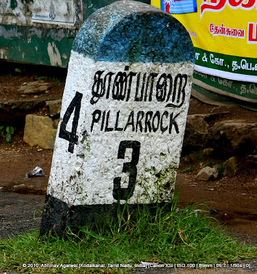
A milestone. Did I mention I photograph these?

Pillar Rocks
Among the must-visit sights in Kodaikanal. It is "8 kilometres (5.0 mi) from the bus-stand, is a set of three giant rock pillars which stand 122 metres (400 ft) high.[40] Managed by the Tamil Nadu Forest Department, The viewpoint can be crowded but is not commercialized. There is an excellent public garden adjacent to the viewpoint." [from Kodaikanal - Wikipedia, the free encyclopedia]
Now, I must add the following: "can be crowded" is a very subjective statement. The fact is that while there is a reasonably large parking lot outside the viewpoint, it can get crowded pretty quickly. Some of the locals were mentioning that peak tourist season, which is pretty much all the summer months, can result in tourist buses and vehicles having to park half a kilometer away from the viewpoint. The viewpoint itself is not very large, and even a dozen people can result in an almost claustrophobic feeling. Each tourist bus can disgorge 50 people, or more. So what do you do? Either go during an off-peak season, like November, or go early in the day, before 9AM. Either way, try and be at this beautiful spot before the throngs of tourists trek their way to this viewpoint.


Raindrops keep falling on my windshield. And what good are raindrops on your windshield if you don't capture them for posterity.

© 2011, Abhinav Agarwal. All rights reserved.

Thursday, March 4, 2010

Jog Falls and the 800 feet sheer drop

I had blogged about Jog Falls in January (link), but I wanted to extract from that post just the section on the 800 feet sheer drop from near the Raja Falls.

Enjoy!

Our intrepid guide, very helpful and cheerful, took us to the north side of Jog Falls, and then past the view point, where a five minute trek, not strenuous at all, took us to the point where a small stream of water forms a small pool of water that then makes it way through a small opening and plunges down as the Raja Falls. To the left right of this point is a huge boulder strategically placed so that it overlooks the Raja Fall. Almost completely over the falls.Now, you do not clamber over the boulder, walk over to the edge and peer over. No sir. Do not try that. Do not. Because you don't want to be wondering, as you go into a 800 feet free fall, "why ever did I do that for?"

So what do you do?
You clamber over to the rock. And then you crawl. On all fours. And your belly. Till you can peer over the precipitous ledge.

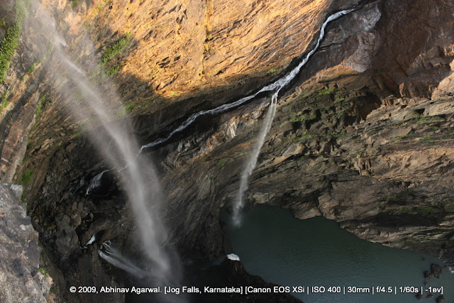
And this is what you would see.
The Raja fall is the one at the top left corner.
And the small white mass of water that you see at the bottom is 829 feet below.

Needless to say, the first time I peered over, I too a peek and then immediately peeled myself back. As far back as I could. The mind has a tough time coming to terms with heights as stark as this. At first. You get the feeling that if you were to peek long enough, you may just, somehow, find yourself tipping down. You won't really, because the ledge does not have a downward slope. But tell that to the mind.
After collecting my wits, I ventured again, this time armed with a camera. And shot off two shots, rapidly, one in portrait and the other one in landscape mode. And peeled myself back.

These two photos are, I believe,  the first ever taken from this vantage point. Till I am corrected.

So let us get mathematical and do some calculations. We want to calculate the time it would take for a person so deciding to take the final plunge to hit the water below. We will ignore the effects of wind resistance. And take the value of 'g' as 9.8 meters per second per second, i.e. g = 9.8 m/s2

Now, the height can be taken as 829 feet, which is 248 meters.
The initial velocity, u, is 0.
So, plug these values into the equation s = ut + 1/2 at2
248 = 0 + 0.5 (9.8 x t2)
or, 50.6 = t2
which gives us 7.11 seconds.

Per the Wikipedia entry on Jog Falls (accessed Jan 1 2010):
Jog Falls (Kannada: ಜೋಗ ಜಲಪಾತ), created by the Sharavathi River falling from a height of 253 meters (829 ft) is the highest plunge waterfall in India[1] Located in Shimoga District of Karnataka state, these segmented falls are a major tourist attraction. It is also called by alternative names of Gerusoppe falls, Gersoppa Falls and Jogada Gundi.[2]
There are many waterfalls in Asia - and also in India - which drop from a higher altitude. But, unlike those falls, Jog Falls is untiered, i.e., it drops directly and does not stream on to rocks. Thus, it can be described as the highest untiered waterfalls in India.


© 2010, Abhinav Agarwal. All rights reserved.

Friday, January 1, 2010

Jog Falls

Jog Falls are the highest falls in India. Located in Uttara Karnataka (north Karnataka), they are a spectacular sight to behold. They can be seen from two sides, and the view from both sides is a sight. To behold. The flow of water in the winter months is vastly reduced when compared with what's there during the monsoons, but that also allows you to see the four falls there more clearly. Each sight has something unique to offer.

The Jog Falls are created by the Sharavati River that plunges down from a height of 829 feet, though some figures put that height at over 900 feet.
Per the Wikipedia entry on Jog Falls (accessed Jan 1 2010)::
Jog Falls (Kannada: ಜೋಗ ಜಲಪಾತ), created by the Sharavathi River falling from a height of 253 meters (829 ft) is the highest plunge waterfall in India[1] Located in Shimoga District of Karnataka state, these segmented falls are a major tourist attraction. It is also called by alternative names of Gerusoppe falls, Gersoppa Falls and Jogada Gundi.[2]
There are many waterfalls in Asia - and also in India - which drop from a higher altitude. But, unlike those falls, Jog Falls is untiered, i.e., it drops directly and does not stream on to rocks. Thus, it can be described as the highest untiered waterfalls in India.

Also see:Jog Falls | World Waterfall Database: World's Tallest Waterfalls
The World's Most Spectacular Waterfalls- Slide 10 - Slideshows - Travel + Leisure


Google Map:

View Larger Map

This is NH206, heading westwards. In the background you can see the bridge that takes you over the Sharavati river and towards the south side of the Jog Falls.


This milepost is actually as you approach Jog Falls from Honnavar. This is also milepost marker 333, which means you are 333 kms from the start of NH206 at Tumkur.


And five kilometers later you can see milepost marker number 328. This is the standard for milepost markers on national highways - a stone marker, with a yellow semi-circular top, and a white cuboidal base. The text is in black. The signage, the text and the numbers, alternate in English, Hindi, and Kannada.


This is the bridge that takes you over the Sharavati river. An old bridge, it looks even more picturesque from afar.


From the bridge you need to drive some 2.4 kms before you actually get to the falls. The drive curves through the Ghats before landing you at the entrance to the Falls, where you pay an entrance fees. The fact that the Falls are not very near any major city also means that there were no more than a hundred tourists there. Which means you can spend time viewing the falls from the viewpoints without having to jostle with hordes of tourists. The preferred mode of transport for the majority of tourists is to take one of the several buses that ply to Jog Falls - tourist or otherwise.


And this is the view from the south side. During the winter months the flow of water is reduced to a trickle, but the sound of these four falls plunging down almost 900 feet is still an impressive roar. The spray however does not reach up. It may, during the monsoons. Each view has its beauty.


There is a walkway, comprising 1600 steps, that you can take to trek down to the base of the falls. Got to try it the next time. Per the guide, the trek down and up and spending some time down takes generally three hours or so.


Lots of people do that, walk down, choosing to bathe in the waters there.


This is the Rocket fall below. The name is derived from the fact that there is a large volume of water that falls down at high speed.


A closeup reveals that there is a large volume of water; in fact of all the four falls, this one seems to have the most volume of water.


And a further closeup reveals that water seems to be rushing out at great speed.


Raja Falls and the view from, shall we say, suicide point?
All of this brings me to the highlight of our visit to the falls. Our intrepid guide, very helpful and cheerful, took us to the north side of Jog Falls, and then past the view point, where a five minute trek, not strenuous at all, took us to the point where a small stream of water forms a small pool of water that then makes it way through a small opening and plunges down as the Raja Falls. To the left right of this point is a huge boulder strategically placed so that it overlooks the Raja Fall. Almost completely over the falls.
Now, you do not clamber over the boulder, walk over to the edge and peer over. No sir. Do not try that. Do not. Because the body's gyroscope is quite likely to err.

So what do you do?
You clamber over to the rock. And then you crawl. On all fours. And your belly. Till you can peer over the precipitous ledge.

And this is what you would see.
The Raja fall is the one at the top left corner.
And the small white mass of water that you see at the bottom is 829 feet below.


Needless to say, the first time I peered over, I peeked and then immediately peeled myself back. As far back as I could. The mind has a tough time coming to terms with heights as stark as this. At first. You get the feeling that if you were to peek long enough, you may just, somehow, find yourself tipping down. You won't really, because the ledge does not have a downward slope. But tell that to the mind.

After collecting my wits, I ventured again, this time armed with a camera. And shot off two shots, rapidly, one in portrait and the other one in landscape mode. And peeled myself back.

These two photos are, I believe,  the first ever taken from this vantage point. Till I am corrected.

So let us get mathematical and do some calculations. We want to calculate the time it would take for a person so deciding to take the final plunge to hit the water below. We will ignore the effects of wind resistance. And take the value of 'g' as 9.8 meters per second per second, i.e. g = 9.8 m/s2

Now, the height can be taken as 829 feet, which is 248 meters.
The initial velocity, u, is 0.
So, plug these values into the equation s = ut + 1/2 at2
248 = 0 + 0.5 (9.8 x t2)
or, 50.6 = t2
which gives us 7.11 seconds.


The bridge, as seen from the north side of the falls.


The Linganmakki dam.
Per the Wikipedia entry on Jog Falls (accessed Jan 1 2010):
Associated with the waterfall is the nearby Linganmakki Dam across river Sharavathi, and the hydro-electric power station that it serves[4]. The power station has been operational since 1949, and is, at 1200 MW capacity, one of the largest hydro-electric stations in India and a significant source of electric power for Karnataka. The power station was previously named Krishna Rajendra hydro-electric project, after the King of Mysore at that time. The name was later changed to Mahatma Gandhi hydro-electric Project. It was served by Hirebhaskara dam until 1960. After 1960, thanks to visions of Sir M. Visvesvarayya, Linganmakki Dam, built across river Sharavathi is being used for power generation.


© 2009, Abhinav Agarwal. All rights reserved.