Showing posts with label bridge. Show all posts

Sunday, July 27, 2014

Vashi Creek Bridge

This photo is of the Vashi Creek Bridge that connects mainland Mumbai with Navi Mumbai. Taken early in the morning, even as the hot summer sun beat down through a haze of smog, pointing the phone's (a Nexus 5) camera slightly up and towards the sun caused the shot to underexpose a little, providing an nice silhouetted look to the composition.


© 2014, Abhinav Agarwal (अभिनव अग्रवाल). All rights reserved.

Saturday, July 14, 2012

Bridge Sign in Madurai

Bad bridge! If the sign does not fascinate you, then surely the gentle admonition should work, "Bad to overtake on the bridge!" This bridge is in the temple city of Madurai, on the way to the massive and amazing Meenakshi Sundareshwar Temple.


© 2012, Abhinav Agarwal (अभिनव अग्रवाल). All rights reserved.

Monday, September 28, 2009

Mathur Aqueduct

If you are visiting Kanyakumari or Trivandrum, the Mathur Aqueduct should be on your itinerary. It is an aqueduct, a hanging aqueduct, the tallest in Asia, and thankfully, not yet overrun by hordes of tourists. You will however still see the occasional tourist bus make its way there.

Wikipedia has an informative writeup on this aqueduct:
Mathur Aqueduct or Mathur Hanging Trough, is an Aqueduct in Southern India, in Kanyakumari District of Tamilnadu state.
Mathur Aqueduct itself carries water of the Pattanamkal canal for irrigation over the Pahrali river, from one hill to another, for a distance of close to one kilometer. This Aqueduct is necessitated due to the undulating land terrain of the area, which is also adjacent to the hills of the Western Ghats.
Mathur Aqueduct is a concrete structure held up by 28 huge pillars, the maximum height of the pillars reaching 115 ft. The trough structure is 7 ft in height, with a width of 7.5 ft. The trough is partly covered on top with concrete slabs, allowing people to walk on the bridge and also see the water going through the trough. Some of the pillars are set in rocks of the Pahrali river, though some of the pillars are set in hills on either side.


As you descend down to the river, you can see rubber trees planted, with rubber sap extraction in process. It is a pity that I was not patient enough to snap a photo of a drop actually falling... There is not likely to be a next time any time soon I am afraid.


© 2009, Abhinav Agarwal. All rights reserved.

Monday, October 23, 2006

Jayadeva Flyover

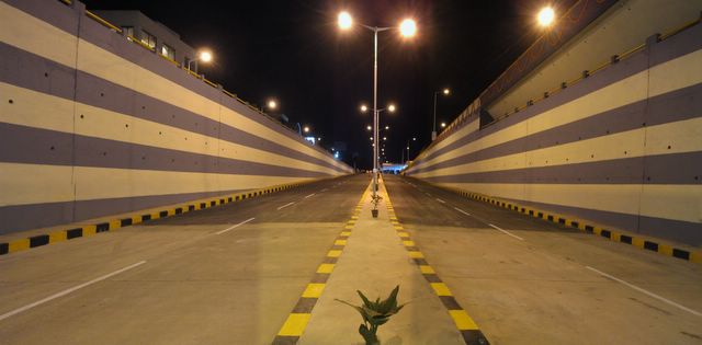
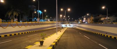
Jayadeva Flyover in Bangalore - the night before it opened to the public.
If you see the flyover now, and the traffic that flows through the underpass, I sure am glad I got this photo for posterity.


This is from near the underpass. If you can spot the plants, it is worth noting that they were gone the next day.


Closer to the underpass, you can see that the combination of yellow lights to the underpass, and white lights in the underpass made for an interesting photograph.


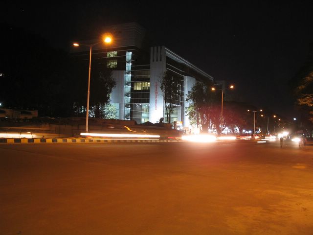
This building on the left is Mantri Commerce. The road near this intersection -of Mantri Commerce and Casa Ansal - is more than six lanes wide...


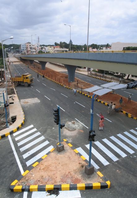
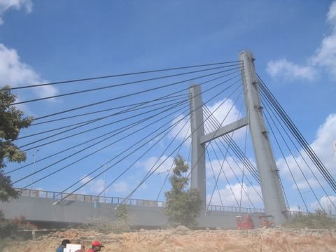
During the day, I also managed to walk up the connector (is that the right word, or is it something else?) and take this photo - this leading towards Jayanagar / JP Nagar.


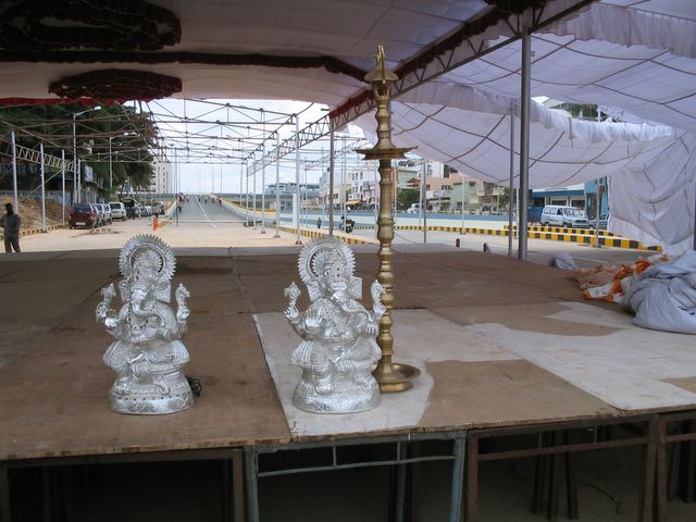
These are the Laxmi/Ganesh idols, to be used for the inauguration of the flyover.


While the city goes to the dogs, thanks to inept, apathetic babus and netas (I had to take a shot :), how could I not snap this dog having a siesta, even as he kept one eye on me (and I both eyes on him).


Any guesses what this granite slab would have had inscribed on it?


This frantic cement pouring work took place the day before the opening of the flyover. And I think this is the last set of photos I have to post on the Jayadeva Flyover - I may do a reprise sometime later...


© 2006, Abhinav Agarwal (अभिनव अग्रवाल). All rights reserved. Re-posted to this blog, June 2013

Sunday, October 22, 2006

Golden Gate Signage

Lots and lots of signs to be seen in and around the Golden Gate. Including this one, on the Golden Gate National Recreation Area, which also includes a long scenic drive along the shore in Marin county.


The day was really nice - warm and sunny, and all along downtown and the piers you could see throngs of joggers.


Among al these, note the blue sign at the lower right bottom, that reads, "There is hope... make the call"


More signage along the Golden Gate bridge.


I really like these bus signs.


© 2006, Abhinav Agarwal (अभिनव अग्रवाल). All rights reserved. Reposted to this blog, July 2013

Saturday, September 9, 2006

Muir Woods

Golden Gate and Muir Woods, 2001 - from my photo archive, so to say.
This and the rest of the photos were taken on a trip to Muir woods.


The Golden Gate bridge, seen through a mist.

Millions of photos of the Golden Gate, and here is another one.


Muir Woods


Looking up a tree, as opposed to a looking glass.


© 2006, Abhinav Agarwal (अभिनव अग्रवाल). All rights reserved. Re-posted to this blog, July 2013.

Thursday, December 22, 2005

Charleston Bridge, Boston

The Charlestown bridge in Boston. I have not been to Boston many times. In fact before this year the last time I was drove through Boston was on my way from Canada to New Jersey, in 2002. And I think this bridge was being constructed at the time.

If you browse to the Mass Turnpike Authority's web site, it will tell you that the official name of the bridge is Leonard P. Zakim Bunker Hill Bridge and that it is over the Charles river. It is a cable-stayed Bridge and that it cost $100 million to construct. Its two towers are 270 feet in height. It's unique shape is attributed to Swiss bridge designer Christian Menn, who conceived the bridge to reflect, with its inverted Y-shaped towers, the shape of the Bunker Hill Monument in neighboring Charlestown. The bridges cables -- which suggest a ship in full sail -- also evoke the history of East Boston as a center of shipbuilding.

The MTA site also will tell you the bridge, at 1,432 feet long, emerges from the underground Central Artery near the Fleet Center at Causeway Street, crossing the river to make connections with both I-93 and Route 1. The bridge is designed to carry 10 lanes of traffic; eight lanes passing through the legs of the twin towers and two cantilevered on the east side. The bridge is also unique. In addition to being the widest cable-stayed bridge in the world, the bridge is the first "hybrid" cable-stayed bridge in the United States, using both steel and concrete in its frame. For more information you should visit the MTA site at http://www.massturnpike.com/bigdig/background/crb.html

Reposted to this blog, Nov 2012
© 2012, Abhinav Agarwal (अभिनव अग्रवाल). All rights reserved.

Monday, November 14, 2005

KR Puram Bridge, Old Madras Road

The KR Puram bridge on the old Madras Road.


The bridge is not as wide or long as one may expect, but very picturesque indeed. It's been two years since I went that side, so no idea how it's weathered the two years since.


© 2005, Abhinav Agarwal (अभिनव अग्रवाल). All rights reserved. Posted to this blog, June 2013